
Interlinkage of Drought, Fire Severity, Vegetation Degradation, and Hydrological Response in Peatland Ecosystems
Article Sidebar
-
Deforestation, Runoff, Drought, Fire Severity, Peatland Ecosystem
Abstract
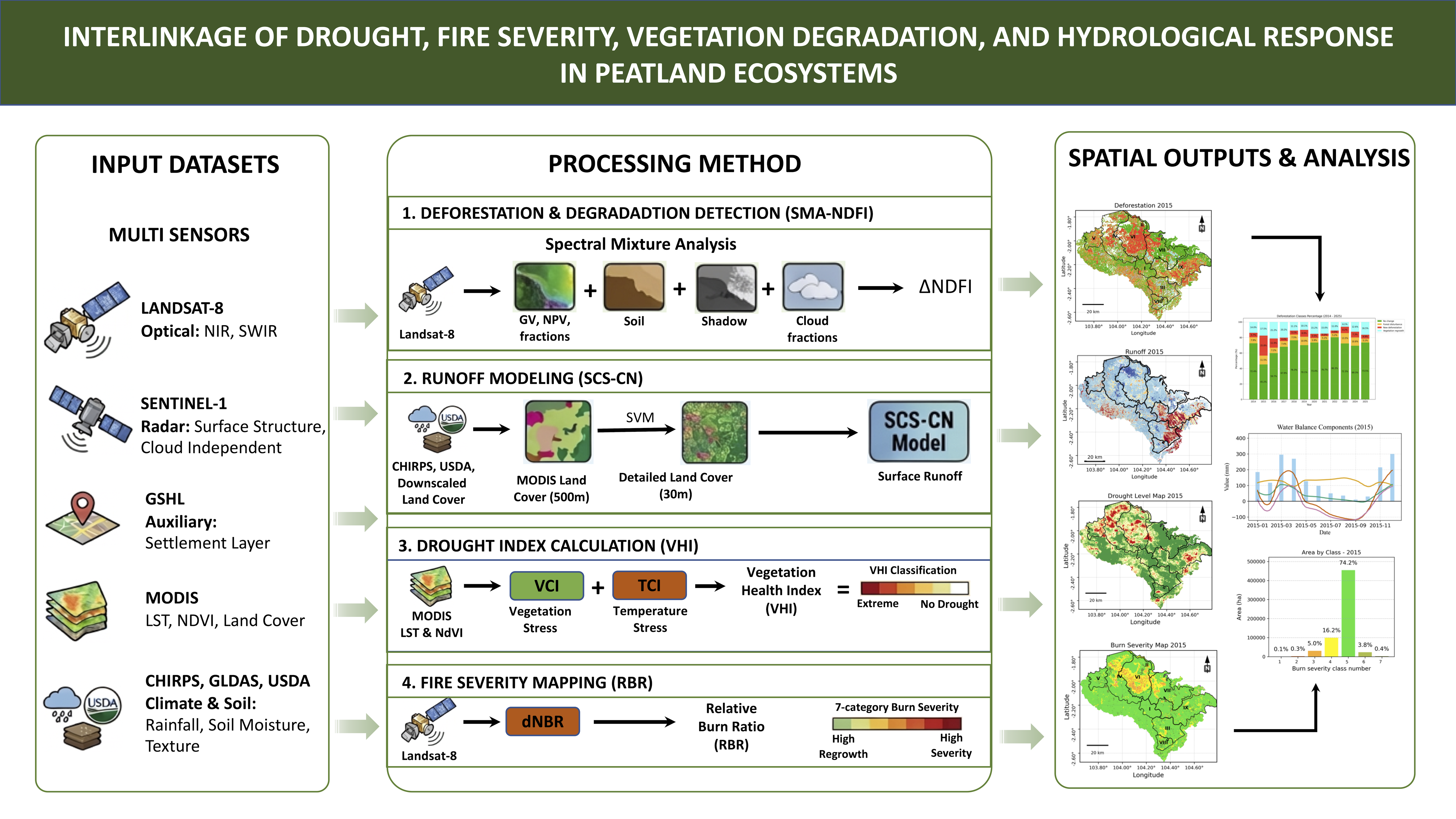
Peatlands, as fragile ecosystems, are vulnerable to deforestation and altered hydrological regimes. The objectives of this study were to evaluate the effects of deforestation on runoff, drought, and fire severity in nine Peat Hydrological Units (KHG) in South Sumatra, Indonesia, in 2014–2025. The deforestation map was created by analyzing the Landsat-8 image through Spectral Mixture Analysis (SMA) and the Normalized Difference Fraction Index (NDFI). The runoff was modeled using the Soil Conservation Service-Curve Number (SCS-CN) method based on downscaled land cover, CHIRPS, GLDAS, and MODIS data. The drought condition was evaluated using the Vegetation Health Index (VHI), and fire severity was evaluated based on the Relativized Burn Ratio (RBR). The findings indicate that in 2015, the most significant deforestation occurred with the value of NDFI decreasing by > 0.25. In 2015, the highest annual rainfall during the study was 1828 mm, with an anomaly of 1-m topsoil moisture reaching −11.35 mm. Extreme drought (VHI < 0.1) occurred in > 35% of the area of S. Merang – S. Ngirawan and S. Lalan – S. Merang watersheds. Also, the 2015 fires had the largest area of moderate and high (RBR > 0.27) compared to the 2019 and 2023 fires. Deforestation also increased hydrologic response in the watershed as the annual runoff coefficient increased from 13% in 2015 to 15% in 2016 due to a decrease in infiltration from vegetation loss. As a conclusion, this study showed that deforestation increased runoff, drought conditions and peat fires. Our findings are important for evidence-based strategies on fire mitigation and hydrological management in tropical peatlands.
References
Almouctar, M. A. S., Y. Wu, F. Zhao, and C. Qin (2024). Drought Analysis Using Normalized Difference Vegetation Index and Land Surface Temperature Over Niamey Region, the Southwestern of the Niger Between 2013 and 2019. Journal of Hydrology: Regional Studies, 52; 101689
Brandão, A. R. A., D. Schwamback, A. S. Ballarin, J. J. Ramirez-Avila, J. G. Vasconcelos Neto, and P. T. S. Oliveira (2025). Toward a Better Understanding of Curve Number and Initial Abstraction Ratio Values from a Large Sample of Watersheds Perspective. Journal of Hydrology, 655; 132941
Bruijnzeel, L. A. (2004). Hydrological Functions of Tropical Forests: Not Seeing the Soil for the Trees? Agriculture, Ecosystems & Environment, 104(1); 185–228
Bullock, E. L., C. E. Woodcock, C. Souza, and P. Olofsson (2020). Satellite-Based Estimates Reveal Widespread Forest Degradation in the Amazon. Global Change Biology, 26(5); 2956–2969
Burka, A., B. Biazin, and W. Bewket (2024). Spatial Drought Occurrences and Distribution Using VCI, TCI, VHI, and Google Earth Engine in Bilate River Watershed, Rift Valley of Ethiopia. Geomatics, Natural Hazards and Risk, 15(1); 2377672
Cortes, C. and V. Vapnik (1995). Support-Vector Networks. Machine Learning, 20(3); 273–297
Datta, A. and R. Krishnamoorti (2022). Understanding the Greenhouse Gas Impact of Deforestation Fires in Indonesia and Brazil in 2019 and 2020. Frontiers in Climate, 4; 799632
Field, R. D., G. R. van der Werf, and S. S. P. Shen (2009). Human Amplification of Drought-Induced Biomass Burning in Indonesia Since 1960. Nature Geoscience, 2(3); 185–188
Friedl, M. A., D. Sulla-Menashe, B. Tan, A. Schneider, N. Ramankutty, A. Sibley, and X. Huang (2010). MODIS Collection 5 Global Land Cover: Algorithm Refinements and Characterization of New Datasets. Remote Sensing of Environment, 114(1); 168–182
Funk, C., P. Peterson, M. Landsfeld, D. Pedreros, J. Verdin, S. Shukla, G. Husak, J. Rowland, L. Harrison, A. Hoell, and J. Michaelsen (2015). The Climate Hazards Infrared Precipitation With Stations—A New Environmental Record for Monitoring Extremes. Scientific Data, 2; 150066
Halbgewachs, M., M. Wegmann, and E. da Ponte (2022). A Spectral Mixture Analysis and Landscape Metrics Based Framework for Monitoring Spatiotemporal Forest Cover Changes: A Case Study in Mato Grosso, Brazil. Remote Sensing, 14(8); 1907
Hasan, A. F., F. Laurent, F. Messner, C. Bourgoin, and L. Blanc (2019). Cumulative Disturbances to Assess Forest Degradation Using Spectral Unmixing in the Northeastern Amazon. Applied Vegetation Science, 22(3); 394–408
Hengl, T. (2018). Soil Texture Classes (USDA System) for 6 Soil Depths (0, 10, 30, 60, 100 and 200 cm) at 250 m (v0.2) [Data Set]
Hou, Y., X. Wei, M. Zhang, I. F. Creed, S. G. McNulty, and S. F. B. Ferraz (2023). A Global Synthesis of Hydrological Sensitivities to Deforestation and Forestation. Forest Ecology and Management, 529; 120718
Huijnen, V., M. J. Wooster, J. W. Kaiser, D. L. A. Gaveau, J. Flemming, M. Parrington, A. Inness, D. Murdiyarso, B. Main, and M. van Weele (2016). Fire Carbon Emissions Over Maritime Southeast Asia in 2015 Largest Since 1997. Scientific Reports, 6; 26886
Kettridge, N., M. R. Turetsky, J. H. Sherwood, D. K. Thompson, C. A. Miller, B. W. Benscoter, M. D. Flannigan, B. M. Wotton, and J. M. Waddington (2015). Moderate Drop in Water Table Increases Peatland Vulnerability to Post-Fire Regime Shift. Scientific Reports, 5; 8063
Kiely, L., D. V. Spracklen, S. R. Arnold, E. Papargyropoulou, L. Conibear, C. Wiedinmyer, C. Knote, and H. A. Adrianto (2021). Assessing Costs of Indonesian Fires and the Benefits of Restoring Peatland. Nature Communications, 12; 7044
Ma, S., S. Zhou, B. Yu, and J. Song (2024). Deforestation-Induced Runoff Changes Dominated by Forest-Climate Feedbacks. Science Advances, 10(11)
Mandailing, P. M., W. Mardiansyah, M. Irfan, A. Arsali, and I. Iskandar (2020). Characteristics of Diurnal Rainfall Over Peatland Area of South Sumatra, Indonesia. Science and Technology Indonesia, 5(4); 136–141
Michel, C., V. Andréassian, and C. Perrin (2005). Soil Conservation Service Curve Number Method: How to Mend a Wrong Soil Moisture Accounting Procedure? Water Resources Research, 41(2)
Miller, J. D. and A. E. Thode (2007). Quantifying Burn Severity in a Heterogeneous Landscape With a Relative Version of the Delta Normalized Burn Ratio (dNBR). Remote Sensing of Environment, 109(1); 66–80
Mishra, S., S. E. Page, A. R. Cobb, J. S. H. Lee, A. J. Jovani-Sancho, S. Sjögersten, A. Jaya, Aswandi, and D. A. Wardle (2021). Degradation of Southeast Asian Tropical Peatlands and Integrated Strategies for Their Better Management and Restoration. Journal of Applied Ecology, 58(7); 1370–1387
Mishra, S. K. and V. P. Singh (2003). SCS-CN Method. In Soil Conservation Service Curve Number (SCS-CN) Methodology. Springer, Dordrecht, pages 84–146
Mockus, V. (1949). Estimation of Total (Peak Rates of) Surface Runoff for Individual Storms. Technical report, Washington, DC
Morresi, D., R. Marzano, E. Lingua, R. Motta, and M. Garbarino (2022). Mapping Burn Severity in the Western Italian Alps Through Phenologically Coherent Reflectance Composites Derived From Sentinel-2 Imagery. Remote Sensing of Environment, 269; 112800
Nikonovas, T., A. Spessa, S. H. Doerr, G. D. Clay, and S. Mezbahuddin (2020). Near-Complete Loss of Fire-Resistant Primary Tropical Forest Cover in Sumatra and Kalimantan. Communications Earth & Environment, 1; 65
Page, S. E., F. Siegert, J. O. Rieley, H. V. D. V. Boehm, A. Jaya, and S. Limin (2002). The Amount of Carbon Released From Peat and Forest Fires in Indonesia During 1997. Nature, 420(6911); 61–65
Parks, S., G. Dillon, and C. Miller (2014). A New Metric for Quantifying Burn Severity: The Relativized Burn Ratio. Remote Sensing, 6(3); 1827–1844
Pertiwi, N., T. W. Tsusaka, N. Sasaki, and E. Gunawan (2021). Peatland Conservation Strategies and Carbon Pricing Possibilities for Climate Change Mitigation in Indonesia: A Review. IOP Conference Series: Earth and Environmental Science, 892(1); 012061
Pesaresi, M., M. Schiavina, P. Politis, S. Freire, K. Krasnodębska, J. H. Uhl, A. Carioli, C. Corbane, L. Dijkstra, P. Florio, H. K. Friedrich, J. Gao, S. Leyk, L. Lu, L. Maffenini, I. Mari-Rivero, M. Melchiorri, V. Syrris, J. Van Den Hoek, and T. Kemper (2024). Advances on the Global Human Settlement Layer by Joint Assessment of Earth Observation and Population Survey Data. International Journal of Digital Earth, 17(1); 2390454
Peña-Arancibia, J. L., L. A. Bruijnzeel, M. Mulligan, and A. I. van Dijk (2019). Forests as ‘Sponges’ and ‘Pumps’: Assessing the Impact of Deforestation on Dry-Season Flows Across the Tropics. Journal of Hydrology, 574; 946–963
Pisner, D. A. and D. M. Schnyer (2020). Support Vector Machine. In Machine Learning. Elsevier, pages 101–121
Potić, I., L. M. Mihajlović, V. Šimunić, N. B. Ćurčić, and M. Milinčić (2022). Deforestation as a Cause of Increased Surface Runoff in the Catchment: Remote Sensing and SWAT Approach—A Case Study of Southern Serbia. Frontiers in Environmental Science, 10; 896404
Rodell, M., P. R. Houser, U. Jambor, J. Gottschalck, K. Mitchell, C.-J. Meng, K. Arsenault, B. Cosgrove, J. Radakovich, M. Bosilovich, J. K. Entin, J. P. Walker, D. Lohmann, and D. Toll (2004). The Global Land Data Assimilation System. Bulletin of the American Meteorological Society, 85(3); 381–394
Roy, D. P., M. A. Wulder, T. R. Loveland, C. E. Woodcock, R. G. Allen, M. C. Anderson, D. Helder, J. R. Irons, D. M. Johnson, R. Kennedy, T. A. Scambos, C. B. Schaaf, J. R. Schott, Y. Sheng, E. F. Vermote, A. S. Belward, R. Bindschadler, W. B. Cohen, F. Gao, J. D. Hipple, P. Hostert, J. Huntington, C. O. Justice, A. Kilic, V. Kovalskyy, Z. P. Lee, L. Lymburner, J. G. Masek, J. McCorkel, Y. Shuai, R. Trezza, J. Vogelmann, R. H. Wynne, and Z. Zhu (2014). Landsat-8: Science and Product Vision for Terrestrial Global Change Research. Remote Sensing of Environment, 145; 154–172
Singh, H., M. A. Alam, P. J. Sharma, and K. S. Rautela (2023). A Comparison of the SCS-CN-Based Models for Hydrological Simulation of the Aghanashini River, Karnataka, India. AQUA — Water Infrastructure, Ecosystems and Society, 72(4); 507–519
Soil Conservation Service (1972). National Engineering Handbook, Section 4: Hydrology. U.S. Department of Agriculture, Washington, DC
Souza, C. M., D. A. Roberts, and M. A. Cochrane (2005). Combining Spectral and Spatial Information to Map Canopy Damage from Selective Logging and Forest Fires. Remote Sensing of Environment, 98(2–3); 329–343
Souza, J. C., J. V. Siqueira, M. H. Sales, A. V. Fonseca, J. G. Ribeiro, I. Numata, M. A. Cochrane, C. P. Barber, D. A. Roberts, and J. Barlow (2013). Ten-Year Landsat Classification of Deforestation and Forest Degradation in the Brazilian Amazon. Remote Sensing, 5(11); 5493–5513
Soverel, N. O., D. D. B. Perrakis, and N. C. Coops (2010). Estimating Burn Severity from Landsat dNBR and RdNBR Indices Across Western Canada. Remote Sensing of Environment, 114(9); 1896–1909
Suhadi, S., I. Iskandar, S. Supari, M. Irfan, and H. Akhsan (2023). Extreme Drought Assessment in Sumatra-Indonesia Using SPI and EDI. Science and Technology Indonesia, 8(4); 691–700
Szumińska, D., S. Czapiewski, and P. Sewerniak (2023). Natural and Anthropogenic Factors Influencing Changes in Peatland Management in Poland. Regional Environmental Change, 23(1); 5
Turetsky, M. R., B. Benscoter, S. Page, G. Rein, G. R. Van Der Werf, and A. Watts (2015). Global Vulnerability of Peatlands to Fire and Carbon Loss. Nature Geoscience, 8(1); 11–14
United States Department of Agriculture, N.R.C.S. (2004). National Engineering Handbook, Part 630: Hydrology. U.S. Department of Agriculture, Washington, DC
Vermote, E., C. Justice, M. Claverie, and B. Franch (2016). Preliminary Analysis of the Performance of the Landsat 8/OLI Land Surface Reflectance Product. Remote Sensing of Environment, 185; 46–56
Whitman, E., M. Parisien, D. K. Thompson, R. J. Hall, R. S. Skakun, and M. D. Flannigan (2018). Variability and Drivers of Burn Severity in the Northwestern Canadian Boreal Forest. Ecosphere, 9(2); e02128
Yule, C. M. (2010). Loss of Biodiversity and Ecosystem Functioning in Indo-Malayan Peat Swamp Forests. Biodiversity and Conservation, 19(2); 393–409
Zeng, J., R. Zhang, Y. Qu, V. A. Bento, T. Zhou, Y. Lin, X. Wu, J. Qi, W. Shui, and Q. Wang (2022). Improving the Drought Monitoring Capability of VHI at the Global Scale via Ensemble Indices for Various Vegetation Types from 2001 to 2018. Weather and Climate Extremes, 35; 100412
Zeng, J., T. Zhou, Y. Qu, V. A. Bento, J. Qi, Y. Xu, Y. Li, and Q. Wang (2023). An Improved Global Vegetation Health Index Dataset in Detecting Vegetation Drought. Scientific Data, 10(1); 338
Authors

This work is licensed under a Creative Commons Attribution 4.0 International License.